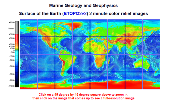
Bathymetry and Topography
These images were generated from the ETOPO2v2 (2006) database. ETOPO2v2 was created at NGDC from digital databases of seafloor and land elevations on a 2-minute latitude/longitude grid (1 minute of latitude = 1 nautical mile, or 1.852 km). Assumed illumination is from the west; shading is computed as a function of the east-west slope of the surface with a nonlinear exaggeration favoring low-relief areas. A Cylindrical Equidistant projection was used for the world image, which spans 360 degrees of of longitude from 180 West eastward to 180 East; latitude coverage is from 90 degrees North to 90 degrees South. The resolution of the gridded data varies from true 2-minute for the Atlantic, Pacific, and Indian Ocean floors and all land masses to 5 minutes for the Arctic Ocean floor. Clicking on a square above brings up a 512 x 512 pixel color relief image of the 45 degree area selected, clicking on the 512 x 512 image brings up the full-resolution 1350 x 1350 pixel (roughly 3 mb) color image of the area.
Bathymetry and Topography Read More »